Saturday, March 29, 2014

Dance, it's Spring!

In Budapest, Erszébet square, March 28:


Now that is what I call folk dance.  I knew before coming here a thing or two about Hungarian folk dance.  The Smithsonian folklore festival in Washington DC last summer featured Hungary, and Josh and I went out to the dance barn there and learned our "ta, ta, ti ti ta."  Those rhythms are now back on display, during the Budapest Tavaszi (Spring) Festivál.  This has made it real easy for us to get down contry style.  The roots revival of folk dance is still going strong since  1970, apparently.  Later the night of this video, I ventured out to a place called Fonó, where average joes were doing this boot-slapping dance.  And I joined a large circle dance which felt like a sped up version of the hora.  


At the other end of the spectrum, weird modern dance is really easy to find now as well.  The night before, we watched an abstract dance video of a woman breaking out of a coccoon, followed by a dance group that looked like pleather astronauts who have just discovered a freaky laser beam synthesizer.  Thank goodness it was free.  We witnessed circus dancing last night, we'll be seeing a multimedia fashion show tonight, and on Tuesday, we'll attend the world premiere of "Mata Hari" the musical.

Also during this spring festival is a chess tournament.  This one is for Daanish.


Aside from the festival, we have been enjoying the heartiness of Magyar food and the well-preserved neo-Gothic buildings, like the fisherman's bastion.  Not to mention the excellent public transportation and the nice apartment we found through Airbnb.  We are definitely enjoying the relaxed pace of our time here.


Friday, March 21, 2014

Plane vs Trains


Well, we've ruled out donkey cart.

Josh and I had to decide last night whether to fly into Budapest from Istanbul or take trains.  This was really hard.  And we are still debating the merits of each.  Your input is very welcome, in the comments here.

Here are the issues with each:

Plane -  Airports are not close to city centers, flying can be a less social and cultural experience than trains, the view from a plane window is too far away to see much detail, and airport security can be annoying.

Trains - There is no direct train - it would instead require at least two connections, we can't buy the tickets beforehand or figure out how to research prices online, would be more expensive than flying, the ticket for each successive segment would have to be bought at the train stations once we got there in local currency, and there would be immigration or customs at each border along the way.  It seems like the trip would take at least 30 hours versus the 1.5 hour flight, and that is if we do not stop to sightsee along the way.

I am more for the plane at this point and Josh prefers the train.  I think that since we've been zipping around so much, we've gotten too used to passing through and not engaging deeply enough with places.  So I suggested that instead of passing through three countries in 2 weeks, we spend the entire 2 weeks in one amazing place.  Passing through Bulgaria and Serbia by train would be doing more, but doing it less well, I think.  Plus the plane seems far easier, cheaper, and after having ridden lots of trains and night buses, the romance of them is starting to wear off for me.

For Josh, the value of seeing the changes in landscape and getting to see the different cultures, even if just at the brief stops at stations along the way, is still very alluring. It helps fit our experiences on either end of the journey into a better mental picture - having pieces connect in a giant cultural jigsaw puzzle. But it does take much longer, would be more difficult, and given the ridiculously low fares offered by budget airlines, would be substantially more expensive. Is it worth it to take a few days to travel between our destinations, even if we only get to see the places between fleetingly?

Tuesday, March 18, 2014

Likya Yolu

Ancient road number 5: the Lycian Way (Likya Yolu in Turkish).  So to be honest, this is not really a road and it is not really ancient.  It is a 510 km collection of footpaths, major streets, mountain trails, beach walks and so on, and it goes across some ancient sites along a southern peninsula in Turkey that used to be the home of the Lycians.

Ruins are pretty disheveled here but the coastal scenery is gorgeous.  We walked one stretch from the coast to a mountain village (used to be a lake but was apparently drained by the Romans).  A goatherd along the way made excellent hissing and screaming noises to clear the goats off the path for us.


When we got to the top of this trail, we were in a village where the only place to stay charged 90 euro per night!  It was a fancy B&B in a really small and not exactly prosperous hill town.  I was kind of embarrassed that the owner would charge that much.  To get out of there, we hitchhiked on the back of a tractor (FUN!) and landed a comfortable room for 50 lira (a fifth of the price) back on the coast.


I think the best part of the actual ancient sites here are the rock cut tombs.  In Myra (now Demre) some have Lycian inscriptions (looks a bit like Greek, but it's not!) and you can climb up into them, as long as you don't mind being barked at by village dogs.  Fortunately for us, we somehow acquired a stray mutt on the walk from the bus station.  He became our loyal friend and defender and visited all the sites with us - about 8km roundtrip!  With him by our side, other dogs seemed far less menacing.


We named him Nikolai by the way.  Why Nikolai?  Because Myra was the bishopric of Saint Nick!  This town definitely claims him as their own, with a Baba Noel museum (the Cathedral of Saint Nicholas) and the market of Santa kitsch.  It was pretty bizarrely excellent to see vendors selling icons of Saint Nicholas for Russian tourists.  And weirder still, the town hall has Santa's jolly face as part of its seal.  Thinking of him as Mediterranean makes me realize how little I know of Santa's actual life.  It definitely messes with the traditional North European-American reindeer and elves thing.


Day after tomorrow, we leave the Lycian Way for Istanbul and further into the Balkans!

Saturday, March 15, 2014

Aegean Village Face-off

From the Central Aegean coast in Turkey, we bring you another episode of Village Face-Off!  Today's match-up: Şirince vs. Beyazköy.  (Actually, its real name is something else but I think I shall keep the name to myself!)  Two small hill towns within driving short distance of the ruins of Ephesus.

This is Şirince:


Some quick stats:  described in the guidebooks as idyllic, well-preserved old Greek town, and increasingly a weekend get away for wealthy turks.  Reachable via shared vans that leave throughout the day from the closest backpacker town.  Hawkers selling lots of fruit wines at 20 Turkish lira a bottle at both shops where we inquired.  Lots of accommodations and restaurants.  Parking lot cost 5 lira per otomobil.  Locals hanging about but not interested in tourists, while hawkers all speak English.  American pop music audible somewhere. 

Overall score: 6/10.  Mostly for the gorgeous hilly scenery and the convenience factor.

And this is Beyazköy:


Some quick stats: not described or listed in guidebooks. Reachable via private transport or maybe a school bus from somewhere.  No hawkers.  No hotels.  No restaurants.  (Trust us, we asked.)  But as with most Turkish villages, there is a tea house across from the mosque in the central square.  Parking is where you can find it.  Locals are outside tending flocks or soaking up welcome midday warmth and are very interested in tourists, but do not speak English.

Overall score: 9/10.  Why so high, you ask?

First of all, the hilly scenery here is just as gorgeous as Şirince, except that there are fewer houses.  


Second of all, even though there is not a restaurant, we were fed well.  While sipping tea, we darted next door and bought a cheap loaf of bread from the village mart.  Seeing this, the tea house man brought out a Tupperware full of local olives and put it on our table, so we ate some of the olives.  They were not very flavorful, though.  The man came over and made it obvious that, instead of eating them, we were supposed to be dipping our bread into the oil in which the olives were floating.  So we did, and oh my god.  Tastiest, freshest, most fantastic olive oil we have ever had.  And he made it himself, from the olive trees growing all around us.  We easily finished off the entire loaf of bread, and the whole meal (bread, olives, oil, tea) cost 2 lira.  One dollar.


We could have eaten more too, because not five minutes later we were being offered food and drink from a lady sitting on a hillock near some sheep.  She waved at us while we were admiring the hillside and so we approached and sat down by her.  In Turkish, she asked us where we were from, and did we think it was cold here in Beyazköy, and had we eaten, etc.  I got her name:  Nadireçam Gölova Menderes.  She laughed at how short my name was in return.  She also laughed at the sheep dung that was on my pant knee, and offered to clean it.  But we didn't want to abuse Nadireçam's hospitality, and we fondly bade her adieu.


I still marvel at the difference between the guidebook village and the unmarked village.  Beyazköy has not been "found," and the only reason we found it is because we had a rental car, Google maps, and a random Spidey sense.  I wonder how the village would change if more tourists began visiting.  For that reason, I've given it an alternate name, just in case Lonely Planet editors lurk on travel blogs.  Whatever happens, I hope Nadireçam stays there for a long time.

Sunday, March 9, 2014

A mountain Too sacred

In the city of Osh, in the country of Kyrgyzstan, on the night of March 8, in an otherwise nondescript cafe, dance music poured out of the front door.  It drew me in, weary as I was of eating in quiet and lonely teahouses.  That is how we ended up stomping to a Kyrgyz remix of Gangnam Style, with hooting teenagers forming a circle around us.  The occasion?  A national holiday celebrated throughout Central Asia, coinciding with International Women's Day.  We had been seeing cheesy TV commercials leading up to this holiday, but did not expect that people would celebrate it so heartily!

But Kyrgyzstan is full of surprises.  Crossing the border by land from Uzbekistan, the first things we noticed were 1) dogs, 2) mountains, 3) people who look a fair bit more east Asian than their Uzbek neighbors.  Tables have soy sauce, all signs are in Cyrillic, and the air is colder.  In fact, the morning after the dancing, we awoke to a snow-covered valley.  The local hill was cloaked in white clouds and it felt like we were thousands of feet higher than we actually were. 


This hill is awesome by the way, and totally worth a visit.  Called "Suleiman Too," it is the "best preserved example of a sacred mountain in Central Asia" according to UNESCO.  I think this lady concurs.


She is sliding down the rock, we're told by a local, because it has healing powers.  The really plump people were especially fantastic to watch, because they slid so smoothly.  Elsewhere on the mountain, people were sticking their arms into holes in the rock, squatting and praying in tiny caves, and exercising.  At the peak, there is a little building with a dome.  Inside the building this dude can tell you all about how the prophet Soloman prayed on this very spot (and as evidence, there are well worn, knee-sized depressions in the stone floor), and how later Babar Shah of Moghul fame built a dome on top of it.  The dude cannot tell you this in English, but his gestures work excellently.  Plus he has a great Kyrgyz hat.


This hat, called an Ak Kalpak, is not a gimmick like some other "traditional costumes" you might see on sale in tourist areas.  People actually wear it.  We saw men and boys were wearing it all over town.  It is probably their version of what a cowboy hat is in America; folksy, stylish, and masculine. 

Our stay with Central Asia's Turkic people winding down, we are excited to hit up their relatives in the Mediterranean. See you in Turkey!

The Layered Silk Road

Post by Josh, with intro by Hammad

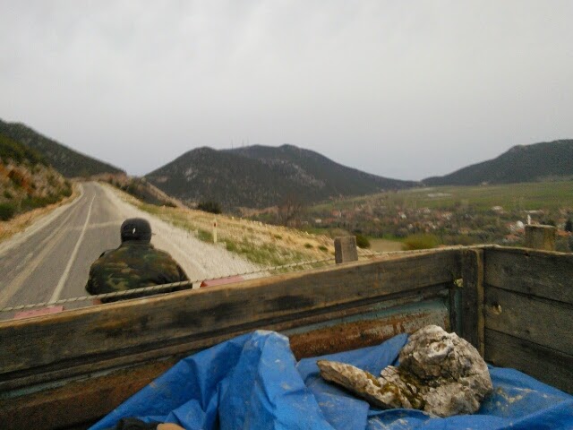
Iran and Russia: two countries we really wanted to visit but could not.  Travel warnings and sanctions got in the way.  But what luck!  Over the last week in Uzbekistan, we have gotten to visit both.  We spent two days in Tajik-speaking, dessert-oasis city Bukhara, where we realized Tajik sounds a lot like Farsi and they are preparing to celebrate Nowruz (pronounced Navrus here), the Zoroastrian-inflected Persian New Year.  Ancient mosques, medressas, canals, mud-brick walls, courtyards, narrow streets and clay tiles surrounded us.  It was something like what I hoped the old cities of Iran might have been.  And then, two nights in Tashkent: the fourth most populous city in the former USSR, and still kicking it Russky-style.  Picture it: a gleaming metro system with station names like "Kosmonavtlar" (astronauts), police with fluffy hats all around, a thriving ballet, imposing buildings, and of course, borsch.  We tried for all we could to see the ballet but the next show was not for two more days.  Lots of things were hard to find, or closed, or both.  Oh well, isn't that part of life in the former Soviet states?

Ancient road number four: the Silk Road.  Between Iran and Russia, this land has seen a slew of different empires, and they stack on top of each other like non (round bread) in a bazaar.  Before the trip, the words silk road conjured images of camel caravans and exotic medieval cities with twisty streets. The actual places are much more complicated.


The Silk Road began around 100 BC, when scouts from China made contact with the empires set up by Alexander the Great in Central Asia. This started an incredibly profitable exchange of good in both directions, with caravans crisscrossing the great Mongolian steppes and goods traveling from Venice all the way to Korea. It was an incredibly difficult 4000 mile crossing, though, and its success was completely dependent upon the fortunes of the wealthy empires that anchored and protected it. The stability of ancient Rome, Han China, and the strong Selucid states in central Asia allowed trade routes to develop strongly through the 2nd Century AD; the collapse of Roman power and the weakening of the middle states in the following centuries made crossing the road both unsafe and less profitable. Trade between Constantinople and the Sassanid Empire in the 9th through 12th Centuries brought the road to its iconic golden age. Under the Pax Mongolica of the 14th Century, the cities and trade of the Silk Road again gained prominence,  but were now undercut by the cheaper maritime silk road (see Singapore) and gradually fell into decline.

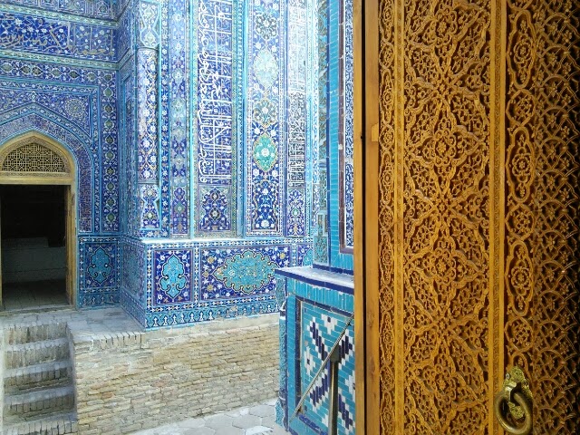
Between these periods of peace, trade, and prosperity, the Road was ravaged by political chaos and warfare, generally as nomadic peoples from the steppes fell on hard times and figured it easiest to survive by sacking their soft city-dwelling neighbors. Samarkand, the glittering jewel of Silk Road stories, was completely destroyed by Ghengis Khan in the 1200s and was only brought back to prominence by the obsessive building efforts of Timur the Lame, another bloodthirsty warlord who destroyed his own share of cities. His great palaces, mosques and madrasas sat on top of the city destroyed by the Khan and within walking distance of the older city of Afrosiab, which was the capitol of the region for a thousand years but fell into decline during the 700s - its eroded mud brick walls still loom behind Timur's creations today. Soviet concrete housing projects and swanky modern tourist hotels make another ring around this. Visiting cities of the Silk Road brings one into contact with all of these layers of time, smashed on top of each other and all deserving of attention.


For the ancient era, Samarkand's bizarre archeological cousin of Afrosiab was our best window into the past. It's currently 400 steeply rolling hills of abandoned dig sites, completely surrounded by city roads and modern neighborhoods. Shepherds guide their flocks over its undulating grassy knolls. Two wild dogs fiercely defended the northwest corner of the area from our curious advances. Archeologists have mapped and excavated temples, palaces, merchant's houses, wells, city walls and gates, and a massive fortified hill castle within the site, but it was all made with mud brick and has eroded back into wildly lumpy hills. Maybe this football-field sized mound was the old merchant's quarter. The taller hill in the back was definitely the castle. Or at least it seems like it was. The only cues that the region was an old city were the irregularity of the hills and the potsherds. The ground was literally covered in them. You could not take a step without crashing fragments of ancient clay several times older than the United States. We wished we could make more sense of the place, but the explanatory museum consisted of two rooms and about that many placards in English. Afrosiab was an intriguing but largely opaque place, hinting at the past but leaving most of it to the imagination.

Our visit to Bukhara was a much more satisfying presentation of the medieval Silk Road. This city was the Capitol of the Samanid Empire in the 10th and 11th centuries and became the center of learning of the Muslim world, filled with glittering mosques, schools, and monuments. These mostly stand today. The city is a living museum, with 140 buildings certified as maintained historical structures from the 9th through 18th centuries. Much of the rest maintains the same character as it did during the late middle ages, with tiny, winding streets and elaborate courtyard houses. Wandering through the tiled squares, in the shadow of ancient mulberry trees and only slightly newer minarets, felt like we were the ones out of place. All we needed were a few more dervishes wandering about and some actual camels in the caravanserais. The monuments and streets were beautiful, while the atmosphere relaxed and mystic.


The trappings of the Road still make themselves felt in the modern towns we have visited. Beneath their Soviet concrete and crumbling roads, the main cities throughout the entire region are basically expanded and modernized Silk Road trading hubs. Strung like pearls along the long mountain valleys that like the region, the towns still have all the diverse languages, peoples, and religions that were brought by centuries of wanderers and profit-seekers.  Ancient mosques and mausolea have shown up in every town. Locals speak three or five different languages to interface with all the groups in their communities. Osh boasts that its marketplace is older than Rome, even though no actual building in the market is much older than the 1980s. And Tashkent still runs a thriving if illicit trade of goods between east and west, though they now tend towards electronics.

We have been incredibly fortunate to explore this region and meet its people. So far, this is the place that we thinkould be most interesting to return to - to explore further into the mountains or out into the desert, and to see what other gems these lands have to offer.


Wednesday, March 5, 2014

Grabbed

Here is a non-comprehensive list of instances we have been grabbed in Uzbekistan:

1.  Grabbed by a businessman and his girlfriend at 3 am as they were passing by us on the street in Tashkent, and invited to an improbable breakfast of shashlyk and lagman as we waited for our train.  Here, by the way, were our cabin mates on the train:


2.  Grabbed by a drunk fellow named Zakero and pulled into an Uzbek wedding in Samarkand where Josh danced with two babushkas.


3.  Grabbed by a crowd of competing dudes as soon as we got off the share taxi in Bukhara, who gave us no choice but to take their bus back to Tashkent, even though it was not parked at the station and was full of sacks of textiles.


Just a tiny sampling of life in Uzbekistan so far.  More to come soon.